Ecliptic coordinate system: Difference between revisions
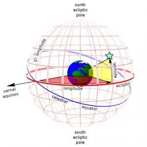
(Created page with "File:440px-Ecliptic grid globe.png|thumb|Earth-centered ecliptic coordinates as seen from outside the celestial sphere. Ecliptic longitude (red) is measured along the eclipt...") |
(No difference)
|
Revision as of 20:50, 5 August 2017

The Ecliptic coordinate system is a celestial coordinate system commonly used for representing the positions and orbits of Solar System objects. Because most planets (except Mercury), and many small Solar System bodies have orbits with small inclinations to the ecliptic, using it as the fundamental plane is convenient. The system's origin can be either the center of the Sun or the center of the Earth, its primary direction is towards the vernal (northbound) equinox, and it has a right-handed convention. It may be implemented in spherical coordinates or rectangular coordinates.
The celestial equator and the ecliptic are slowly moving due to perturbing forces on the Earth, therefore the orientation of the primary direction, their intersection at the Northern Hemisphere vernal equinox, is not quite fixed. A slow motion of Earth's axis, precession, causes a slow, continuous turning of the coordinate system westward about the poles of the ecliptic, completing one circuit in about 26,000 years. [1]

