Doggerland
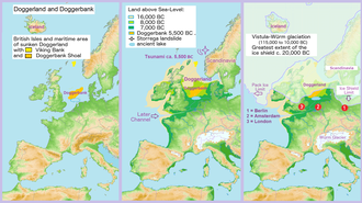
Doggerland was an area of land, now submerged beneath the North Sea, that connected Britain to continental Europe. It was flooded by rising sea levels around 6500–6200 BCE. The flooded land is known as the Dogger Littoral. Geological surveys have suggested that it stretched from what is now the east coast of Great Britain to what are now the Netherlands, the western coast of Germany and the Danish peninsula of Jutland. It was probably a rich habitat with human habitation in the Mesolithic period although rising sea levels gradually reduced it to low-lying islands before its final submergence, possibly following a tsunami caused by the Storegga Slide. Doggerland was named after the Dogger Bank, which in turn was named after 17th-century Dutch fishing boats called doggers.

The archaeological potential of the area was first identified in the early 20th century, and interest intensified in 1931 when a fishing trawler operating east of the Wash dragged up a barbed antler point that was subsequently dated to a time when the area was tundra. Vessels have since dragged up remains of mammoths, lions and other animals, and a few prehistoric tools and weapons.
Discovery and investigation by archaeologists
The existence of what is now known as Doggerland was established in the late 19th century. The remains of plants brought to the surface from Dogger Bank were studied in 1913 by Clement Reid, and the remains of animals and worked flints from the Neolithic period had also been found. [2] [3]